Journey to the Great Wood
- Hannah
- Jan 29, 2021
- 6 min read
Updated: Mar 28, 2021

A longer and more challenging walk with rewarding vistas. There’s a nice mix of scenery and pathways on this one, from a flat meandering stroll between Otford and Shoreham to start off leading to steep hills and steps through woodland further along. Visit Castle Farm’s friendly beef herd at Dunstall Farm en-route and enjoy views of London through the Darent Valley on a clear day.
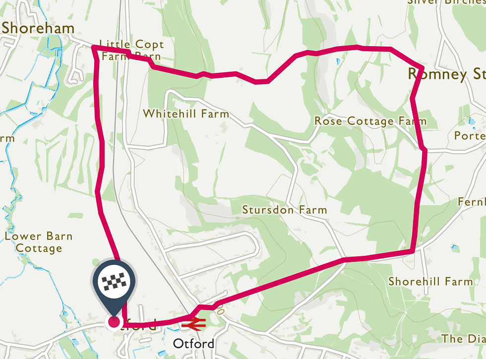
Starting Point: Otford Recreation Park, TN14 5PG
Difficulty: Hard
Length: 5.6miles / 9.0km
Highlights: Darenth Valley Golf Course, Dunstall Farm, valley viewpoints, The Great Wood, Otford Mount, Otford village pond.
Route: Most of the walking on this route is off-road - through fields and along dirt tracks which can get pretty muddy, there are also some steep inclines and declines and steps to climb and traverse so this route isn’t suitable for pushchairs or anyone looking for an easy walk underfoot. It is, nevertheless, a fantastic 2-3 hours spent in some beautiful and peaceful surroundings.
Parking: If travelling from elsewhere, the best place to park in Otford is the Village Hall/Recreation ground car park. It’s pay and display for over an hour and free on Sundays but make sure you take a ticket from the machine even if you don’t need to pay to prove your arrival time. The car park is of a generous size but it does get busy, especially on a nice day. If that’s the case, there is free street parking throughout the village but please park responsibly. Alternatively, Otford station is close by and there are several bus routes serving the area. If you’re in the Shoreham area, you can pick this walk up at Step 2 to save the journey to Otford.
Refreshments/facilities: There are various pubs and cafes in Otford at the start of the walk, and more in Shoreham if you fancy venturing into the village en-route but aside from that, this walk is pretty rural so make sure you’re prepared before you head off.

Step 1
Start at Otford Village Hall and walk through the right hand edge of the recreation ground, away from the village. Towards the far side of the park, after the football pitches, you may notice some stone plinths. It’s the Otford Solar System - a full-scale representation of the position of our planets, and probably the largest model of its type in the world. It was constructed by the village as a millennium project and the Sun, Mercury, Venus, Earth and Mars and Jupiter all sit within the recreation ground. The other planets are further afield elsewhere in the village. When you reach the edge of the park, exit onto park lane via a gate to your right. Turn left and continue to follow the track straight ahead for almost 2km until you reach Shoreham. You’ll pass by some beautiful fields, paddocks, Shoreham Cricket Club and the grounds of Darenth Valley Golf Club before emerging on the outskirts of Shoreham on Station Road.
Step 2
Turn right onto Station Road and continue underneath the railway bridge until you reach the main road (A225). Carefully cross the road and look for the footpath. It’s on your left after the house and is marked with a stone footpath marker and a bridleway sign. Follow the footpath to traverse the hill, keeping left when the footpath branches. You’ll walk through a wooded area and the path will turn to steps. At the top of the steps, give yourself a pat on the back and catch your breath before continuing straight ahead (you’ll come out onto a wider track but don’t be tempted to follow it left or right, just cross straight over). In a few meters you’ll come out in a field and should be able to see Dunstall Farm in front of you (unless it’s super foggy like it was for me), continue across the field towards the farm.

Step 3
Once you reach Dunstall Farm there is clear signage which will guide you through the farmyard and out the other side. The farm is home to the better known Castle Farm’s beef cattle. The residents may be inside a building on your left called the Roundhouse. It was built here in 2008 and it’s said that this kind of circular layout creates a calming environment for the cattle. Remember that this is a working farm, and private land, and therefore you should not venture off the public footpath. When you reach the edge of the farmyard, follow the footpath signs to continue along a track road for 150m. At this point, the path will split with a bridleway straight ahead and a footpath diagonally across a field to the left. Take the route to the left, crossing the field and then walking through a short wooded area before climbing a stile into what was Austin Lodge Golf Course.

Step 4
From the stile, walk (or slip!) straight ahead down a fairly steep hill and climb another stile at the bottom. The footpath will take you through a beautiful tree tunnel offering great photo opportunities in all seasons! At the end of the tunnel, continue to follow the path straight up a steep hill at the edge of a field. Walk through a gap in the bushes and continue up the other side of the valley. After 400m you’ll reach a stile but before you climb it, turn around to admire the view through the valley. On a clear day you can see London and much more from here. You’ll also be glad to know that that’s it for the hill climbing on this walk!
Step 5
Climb the stile and walk along the fence lined footpath until you reach a bridleway on your right, turn right and continue along this path. You’re right by the hamlet of Romney Street, and those of you who’ve done some of our other walks might recognise it as several of them pass through here. If you’re hoping to do a longer walk, try combining two of them, using Romney Street as your crossroads. After 200m you’ll reach a clearing, you need to take the gate on the left hand side into a field instead of the right hand one which is more straight ahead. Walk across the field, keeping to the footpath which runs along the left hand side. Go through another gate and follow the path until you reach a road.

Step 6
If your humour is anything like mine, or you have children with you (more likely!), then you may enjoy the fact that this road is called Magpie Bottom. Turn left and walk along the road, then enter another field via a stile almost immediately on your right. The footpaths in this field are a little tricky as they split and the path we need to follow is less pronounced so make sure you keep left, continuing straight ahead from the stile and parallel to the edge of the field instead of on a diagonal. If you reach a line of trees with a footpath sign in front of them then you’ve done it right! Continue straight ahead from this tree to the bottom corner of the field and climb the stile.
Step 7
You should now have a pretty good view of Great Wood in front of you. Other than the impressively tall trees, I wasn’t able to find much information on why the woods were named as they are - I’ll leave it to you to come up with your own theories whilst walking through! From the stile, traverse the slope diagonally to reach the far bottom corner where you’ll find another stile into the wood. Follow the path through the Great Wood until you reach Birching Cross Road, then turn right and walk carefully along the tree-lined road for 500m until you reach a junction.

Step 8
Straight ahead of you, in between the two adjoining roads you’ll see a gate signposted the North Downs Way. Follow this route along the left hand edge of the field before entering a wooded area. From here, you’ll be heading down Otford Mount and back into the village and the slope will eventually turn into steps. Around half way down, on your right hand side, there’s a bench and a gap in the trees - check it out for a great view of the village and surrounding area.
Step 9
At the bottom of the hill, you’ll emerge on Pilgrim’s Way East. Cross the road and turn right then turn left and walk along Station Road back into the village. You’ll pass the station on your left and then come to Otford village pond, a picturesque spot with some surrounding cafes, shops and pubs. If you’ve walked up an appetite, it’s a great place to stop for a well earned coffee, pint or Sunday lunch before heading back to the car park. If you’ve enjoyed this walk, don’t forget to leave comments and use #darentvalleywalks to show us your pics on social media!

Download printable PDF instructions:
Follow this route in OS Maps:
* Please remember to follow the countryside code and behave respectfully and responsibly when enjoying these routes *


Comments